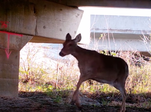
In late February, the Missouri Department of Transportation published a final report about its Wildlife-Vehicle Collision (WVC) Study and Prioritization Project; the culmination of almost two years of research aimed at making state roads safer for both motorists and wildlife alike.
[Above photo by MoDOT]
The agency described this research as “extremely pertinent” as, from 2019 to 2023, Missouri suffered 17,609 WVCs with 8 to 10 percent of them resulting in an injury or fatality. The state also ranked 17th in the nation for WVCs in both 2024 and 2025, according to the agency’s study.
“Knowing where those [WVC] locations are, and knowing when there is overlap between planned projects and collision areas, [can help us] incorporate mitigation measures to help drivers stay safe,” explained Caleb Knerr, a senior environmental specialist with MoDOT, in a news story about the agency’s research.
The agency split its WVC research – which relied in part on grant funding from the Federal Highway Administration’s Wildlife Crossings Pilot Program – into two phases.
The first, which began in fall 2024, analyzed key findings from extensive data collected by the Missouri Department of Conservation and the Land Learning Foundation. That process entailed feeding previously collected datasets of vehicle collisions, carcass reports, and habitat studies, into an “Optimized Hot Spot Analysis” or “OHSA” tool developed by Environmental Systems Research Institute or ESRI, which mapped thousands of potential WVC hotspots statewide.
[Editor’s note: Safety initiatives like this one reflect one of the key emphasis areas of Russell McMurry, commissioner of the Georgia Department of Transportation, for his 2025-2026 term as president of the American Association of State Highway and Transportation Officials.]
MoDOT combined this data with 25 established “priority species” listings and subsequently identified 627 of the most critical vehicle-wildlife conflict hotspots across the state that required mitigation strategies.
This is where phase two of the study kicked in, as researchers evaluated and classified the top 10 hot spots based on land use, constructability, and funding – details gleaned from both a cost-benefit and environmental analysis of each location focused on finding the most reasonable implementation strategy.
MoDOT added that it is confident this study will help provide a “statewide blueprint” for planning and building wildlife crossing infrastructure and for incorporating wildlife considerations into the agency’s future planning, design, construction, and maintenance operations.