
Before a construction crew can build a road, a transportation archaeologist often must reconstruct the history of the ground it’s being built upon. This is the first of a two-part series that digs into that process.
[Above photo courtesy of the University of South Alabama Center for Archaeological Studies.]
The National Historic Preservation Act of 1966 mandates that states must consider a federally funded transportation project’s effects on any site that is listed or may be eligible for listing on the National Register of Historic Places. Usually, the only way to find out if a site is eligible is through an environmental assessment, which includes a survey of cultural resources.
“We first do a literature review and check the historic preservation office – all states have a historic preservation office,” said Erica Schneider, assistant environmental administrator for the Ohio Department of Transportation. “We’ll go out and do an archaeological survey of the area – that’s called identification. If we find sites, we have to determine if they’re eligible and if they’re significant, and what effect the project would have on the site.”
While this process has been characterized by some as a speed bump to faster project delivery, many of the United States’ artifacts and history would have remained buried if not for state department of transportation archaeologists.
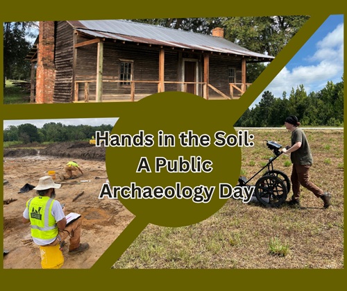
[Editor’s note: Many state DOTs seek to engage the public more deeply in their archeological work. For example, in November 2025, the Georgia Department of Transportation and the Forest Grove Preserve hosted a “Public Archaeology Day” at the historic Harper House in Sandersville, GA, to offer new insights into the daily lives of people who lived and worked in rural Georgia over the past 150 years.]
“There’s a huge value in this, giving us a bigger, broader picture of what’s out there,” explained Schneider, who also serves as chair of the Cultural Resources Subcommittee within the Committee on Environment and Sustainability for the American Association of State Highway and Transportation Officials.
“I think transportation archaeology contributes – and continues to contribute – to archaeology as a whole,” she said.
A few examples of the notable intersections between transportation and archaeology include:
· In 1974, work halted on a planned expansion of U.S. 49 in Mississippi when a midden – an ancient refuse pile – was discovered. Further investigation revealed the pile may date back 6,000 years. Today, the site is known as the Pocohontas Mounds and bears a historical marker erected by the Mississippi Department of Transportation.
· In 2007, 16,000 artifacts from a 19th-century-era homestead were discovered in the path of highway project in Maryland. The findings revealed that the inhabitants of the homestead called on West African spirits to protect their home.
· In 2021, an archaeological dig at an interstate project in Idaho revealed evidence of Kootenai Indian tribal activity thousands of years earlier than first thought. The findings earned the Idaho Transportation Department the 2024 AASHTO President’s Transportation Award for Equity.
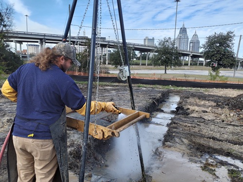
· From 2021 to 2023, archaeologists excavated 15 sites at the planned location of the I-10 Mobile River Bridge and Bayway Project in Alabama. The findings tell the story of Mobile from its days under French, Spanish, and British control in the 18th century to Native American communities from 2,000 years ago.
Transportation engineers’ jobs are to plan, build and maintain roads and bridges, and archaeologists’ jobs are to ensure history is not paved over. Occasionally but inevitably, there is a rub between them.
Schneider said conflicts are more likely to occur when state DOTs “are still siloed” but most agencies now encourage divisions to work together as one team.
“One of the things I’ve learned is the importance of communication and working with people in those other worlds, the engineers and the planners, and to communication with them early on,” Schneider said. “We can come in and say, ‘Maybe we can tweak the road just a bit.’ It can be a real challenge, but I think it’s probably gotten better over the years.”
In Mobile, the need for the bridge project was undeniable. The existing tunnel beneath the Mobile River and the adjacent bridge that crosses Mobile Bay were carrying three times the designed traffic capacity of the structures.
But false starts and intermittent opposition kept the project in various stages of planning for nearly 30 years. After Hurricane Katrina in 2005, new Federal Highway Administration guidelines meant the Alabama Department of Transportation would have to raise and replace the 7.5-mile bay bridge instead of simply adding lanes, adding even more costs until the project’s price tag seemed to settle at $3.5 billion.
Then, there was the history.
ALDOT knew the project site was in a culturally significant part of Mobile, the oldest permanent settlement in French Colonial Louisiana. Fort Conde, built by French explorers in 1723, “is a stone’s throw from the mouth of the tunnel,” ALDOT Media and Community Relations Bureau Chief Tony Harris said.
“I think there was every expectation that we’d find something,” Harris said.
The bridge project site temporarily turned into a major archaeological site that eventually would yield surprising insights into Mobile’s history.
In part two of this story, to be published next week, ALDOT details how its work on the I-10 Mobile River Bridge and Bayway Project unearthed interesting history about the region.
 Archaeology
Florida DOT Archaeologists ‘Dig’ the Museum Scene
March 25, 2026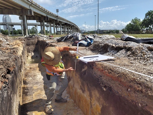 Archaeology