
The North Carolina Department of Transportation recently hosted its first round of community meetings for its proposed “Solving Access for N.C. 12 in Dare County” or SAND Plan.
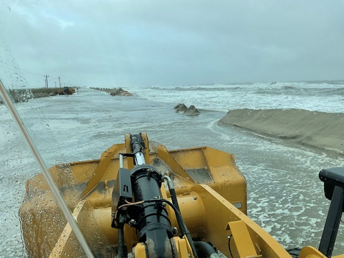
[Above photo by NCDOT] The SAND plan addresses an 11-mile stretch of state highway N.C. 12 in Dare County, between the Marc Basnight Bridge and the Rodanthe “Jug Handle” Bridge, connecting communities along the Outer Banks barrier islands. That segment of N.C. 12 suffers from frequent floods and “overwash” from coastal storms – causing erosion and roadway damage, NCDOT said.
The agency is using the Planning and Environment Linkages or PEL process to streamline future environmental reviews under the National Environmental Policy Act or NEPA. Building on previous efforts such as the N.C. 12 Task Force and past NEPA reviews, NCDOT said its SAND Plan seeks to evaluate practical solutions based on environmental and community considerations, cost, and feasibility in order to provide both long- and short-term roadway solutions.
[Editor’s note: The drone video below gathered by NCDOT provides an overview of the type of damage storms can cause to this exposed segment of N.C. 12.]
The NCDOT recently hosted three public outreach meetings for members of the Outer Banks community across three islands in late April – part of the agency’s pre-construction process. “We’re trying to create…a sense of urgency to get some feedback [and] to see what folks are open [to] and what [are] non-starters,” explained Lindsay Crocker, NCDOT project manager, in a local news release. During a public meeting for Hatteras Island and Rodanthe Islands community members, residents were invited to study NCDOT-provided display boards regarding the project. In-person meeting attendees could also provide comments and questions directly to NCDOT representatives in attendance as well as fill out a project public input survey. Those who could not attend could fill out an online version of the survey by May 15.
The agency added that the next steps for the SAND Plan will include a second and third round of public meetings, scheduled for July and December, respectively. Data collection will begin June 2026, with a complete planning report scheduled for June of 2027, NCDOT said.
 Resilience